Log in
All resources
Create a design
1,085 Free Artworks of Carts In France
bibliothèque nationale de france
tresor des cartes geographiques (1659)
cartes de franz schrader
franz schrader
semeuse stamps on covers and postcards (5c)
cartes de visite of france
félix robaut
maps of french algeria
semeuse stamps on covers and postcards (10c)
maps of barbary coast by mercator-hondius
atlas - voyage pittoresque à l'île-de-france, au cap de bonne-espérance et à l'île de ténériffe (1812) by milbert
maps from the mechanical curator collection
geography of adrar province
cartes de franz schrader
avenue des charmilles (montfermeil)
postcards of montfermeil
old maps showing the history of the former colonies of france
cartes de franz schrader
série aveyron pittoresque
postcards of aveyron
semeuse stamps on covers and postcards (10c)
postcards of favières
cartes de franz schrader
franz schrader
cartes de franz schrader
forez
carte de barbarie, nigritie, guinée par guillaume delisle (1707)
bibliothèque nationale de france
tresor des cartes geographiques (1659)
17th-century maps of silesia
bridges in morbihan
tramway de lorient
old maps of île-de-france
1785 maps of france
academic art,neo-grec,orientalism,neo-pompeian
jean-léon gérôme in portraits
drawings by ingres in the musée ingres
romanticism,neoclassicism
cartes de franz schrader
old maps of kolkata
tresor des cartes geographiques (1659)
1650s maps of india
photographs by étienne carjat
léon gambetta
1862 paintings by camille pissarro
impressionism,neo-impressionism
historical images of limoges
tramway de limoges
tresor des cartes geographiques (1659)
1650s maps of iran
tresor des cartes geographiques (1659)
1650s maps of portugal
tresor des cartes geographiques (1659)
1650s maps of the americas
tresor des cartes geographiques (1659)
1650s maps of denmark
tresor des cartes geographiques (1659)
1650s maps of ethiopia
tresor des cartes geographiques (1659)
1650s maps of china
tresor des cartes geographiques (1659)
1650s maps of asia
tresor des cartes geographiques (1659)
1650s maps of italy
tresor des cartes geographiques (1659)
1659 maps of africa
tresor des cartes geographiques (1659)
1659 maps of europe
tresor des cartes geographiques (1659)
1650s maps of greece
tresor des cartes geographiques (1659)
1650s maps of turkey
tresor des cartes geographiques (1659)
1650s maps of hungary
tresor des cartes geographiques (1659)
1650s maps of the americas
historical images of puducherry (city)
cartes de franz schrader
les causses, les cévennes
cartes de franz schrader
semeuse stamps on covers and postcards (5c)
postcards of gamaches
cartes de franz schrader
diagrams of the alps
topographic maps of alsace
cartes de franz schrader
cartes de franz schrader
diagrams of mountains
cartes de franz schrader
dombes
paintings by paul cézanne in the musée d'orsay
post-impressionism
lucas janszoon waghenaer
bretagne in the 1580s
1770s maps of china
1779 maps
maps of mountains of cantal
cartes de franz schrader
cartes de franz schrader
old maps of algeria
tableaux historiques de la révolution française (portraits)
prints on the french revolution
old maps of the battle of waterloo
achille tenaille de vaulabelle
tresor des cartes geographiques (1659)
1650s maps of eastern europe
tresor des cartes geographiques (1659)
1650s maps of the tsardom of russia
tresor des cartes geographiques (1659)
maps facing east
tresor des cartes geographiques (1659)
17th-century maps of siberia
tresor des cartes geographiques (1659)
old maps of tunis
tresor des cartes geographiques (1659)
1650s maps of the world
photographs by andré adolphe eugène disdéri
mathilde bonaparte
carte particulière des postes de france dediée au roy par son très humble, tres-obéssant, tres-fidele sujet et serviteur - hubert jaillot.... 20 petites lieues de france (1 - 1 800 000 environ) - btv1b8492995r
bibliothèque nationale de france
carte particulière des postes de france dediée au roy par son très humble, tres-obéssant, tres-fidele sujet et serviteur - hubert jaillot.... 20 petites lieues de france (1 - 1 800 000 environ) - btv1b8492995r
bibliothèque nationale de france
historical images of rue du bac (paris)
charles carey
historical trams in dijon
pont de l'hôpital (dijon)
semeuse stamps on covers and postcards (15c)
tramway de sedan
theatre geographique du royaume de france (1632)
maps of perigord
bibliothèque nationale de france
félix robaut
bibliothèque nationale de france
félix robaut
bibliothèque nationale de france
félix robaut
bibliothèque nationale de france
félix robaut
cartes de franz schrader
maps of pays de caux
cartes de franz schrader
old maps of the alps
semeuse stamps on covers and postcards (5c)
postcards of favières
cartes de franz schrader
si phan don
cartes de franz schrader
maps of vosges mountains
cartes de franz schrader
ballon d'alsace
maps of the strait of dover
cartes de franz schrader
historic maps of antsiranana
cartes de franz schrader
découpage électoral français de 1831
postcards of issoudun
1917 in indre
historical images of saint-vallier (drôme)
postcards of drôme
railway coaches of france
gare de privas
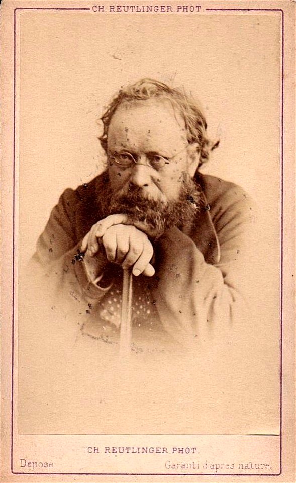
portrait photographs by charles reutlinger
portraits of pierre-joseph proudhon
semeuse stamps on covers and postcards
postcards of lagny-sur-marne
postcards of lagny-sur-marne
postcards with leporello
cartes de franz schrader
old maps of oran
tresor des cartes geographiques (1659)
1650s maps of the ottoman empire
17th-century maps of the malay archipelago
tresor des cartes geographiques (1659)
maps of candia by ortelius and mercator
tresor des cartes geographiques (1659)
tresor des cartes geographiques (1659)
17th-century celestial maps
tresor des cartes geographiques (1659)
maps of guinea by mercator-hondius
tresor des cartes geographiques (1659)
17th-century maps of morocco
tresor des cartes geographiques (1659)
old maps of the whole peloponnese
tresor des cartes geographiques (1659)
1650s maps of the iberian peninsula
tresor des cartes geographiques (1659)
17th-century maps of scandinavia
tresor des cartes geographiques (1659)
17th-century maps of morocco
tresor des cartes geographiques (1659)
17th-century maps of the arctic
maps of barbary coast by mercator-hondius
tresor des cartes geographiques (1659)
tresor des cartes geographiques (1659)
maps of cyprus by mercator-hondius
tresor des cartes geographiques (1659)
17th-century maps of the british isles
tresor des cartes geographiques (1659)
1650s maps of the holy roman empire
maps of barbary coast by mercator-hondius
tresor des cartes geographiques (1659)
paul-albert besnard
symbolism
jean-fréderic phélypeaux
guillaume dheulland
drawings from france in the cleveland museum of art
barbizon school
19th century maps of landes
cartes de franz schrader
201 - 300 of 1,085
Next page
/ 11